
I’ll also play Part 2 of our three-part climate change presentation. Today I share a presentation by Dr. John Pomeroy of the University of Saskatchewan and the newly created cold water climate centre in Canmore, Alberta
Story 1 – Microburst Pounds the Bow Valley
On the evening of June 8, I was getting ready to head out to the climate change presentation that I’ll play during the second portion of this episode, and wouldn’t you know it, minutes before I left the house, an extremely severe storm hit Canmore. It delayed the presentation as people were delayed as traffic slowed to a halt with the torrential rainfall.
Little did I know that a little further west, along the Bow Valley Parkway in Banff National Park, a massive microburst was creating mayhem near to the Johnston Canyon campground and chalets.
A microburst hits like a weather bomb. A wet microburst hits like a tornado but lacks the rotational movement. Think of it as a super intense downdraft of sinking air that hits the ground like a hammer. These downdrafts usually come with mind-boggling amounts of moisture and winds in excess of 100 km/hour.
Like a tornado, microbursts are extremely local events, usually only affecting a few 100 metres to a few kilometres in size. The following image shows a graphic depiction of a microburst.
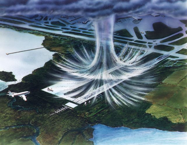
Climatologists have defined them as extreme downbursts that extend no more than 4 km over the surface. It’s small scale, results in much higher wind speeds.
They’re caused by a huge change in air pressure and the air picks up speed as it descends. Essentially, when a large storm happens, dry air draws moisture from the wet air. This cools the wet air and it begins to sink. The bigger the difference in moisture, the bigger the difference in the air pressure. This cool, low-pressure air drops like a stone.
Here’s a high-res aerial photo of an amazing microburst over south Phoenix #azwx #monsoon pic.twitter.com/EWvfZUJpDu
— “That Chopperguy Show” You Tube (@chopperguyhd) July 19, 2016
As the downdraft descends, it accelerates. When it hits the ground, it bursts outward and accelerates even faster increasing the potential for damage from the high winds even more.
In this particular case, the epicentre was just east of Johnston Canyon along the Bow Valley Parkway in Banff. When I visited on Monday, I explored a little of the impact zone and it was absolutely impassable. Almost every tree was either snapped off or uprooted within an area covering almost 10 hectares.
When the storm hit around 5 pm, the debris began flying almost immediately. While the burst was focused primarily east of the campground and resort, a number of trees damaged 90-year-old cabins at Johnston Canyon Resort.

In the campground, falling trees caused the evacuation of 100 campers from the Johnston Canyon Campground to Tunnel Mountain in Banff for safety.
The storm took out power lines and dozens of trees blocked the Parkway. I do a regular nature walk that passes the site of a small microburst that happened years ago, but this scene really helped me to understand the power of a large-scale event.
Events like this have been historically rare in the mountains, but they do happen. However with warming climates, we get more extreme storms on a more regular basis. Currently, the Rockies is receiving more moisture than it did historically, but it’s getting it in fewer, more extreme events.
Globally, microbursts have resulted in numerous commercial plane crashes during takeoffs and landings.
Understanding weather and the implications of events like microbursts can help us to stay safe in the mountains. When hiking, it’s becoming more and more important to keep your eyes on the sky. Look for sudden changes in weather and air pressure.

In the mountains, we often are unaware of an approaching storm until it appears over the top of the nearest mountain. This storm has illustrated just how scary severe storms can be and we all need to take extra precautions in these changing times.
In the Rockies, we often have warm air rising over the course of the day, condensing around the mountain tops. This ‘orographic’ or mountain weather often causes short-lived, extreme thunder storms in the late afternoon or early evening, as was the case in this storm.
Coincidentally, this is often just about the time many hikers are crestingthe summit ridge on a long walk. If you can see visible changes in the cloud cover, or sudden changes in the direction of winds, it may indicate a coming change in the weather. Take the time to learn a little more about predicting the weather when you’re exploring the mountains. If you hike a lot, it will definitely pay off in the long run.
Story 3 – High Mountain Climate Change with Dr. John Pomeroy
Dr. Pomeroy recently received the largest water research grant in the world to start the Global Water Futures. It’s focused on the impacts of climate change on water systems and will look at helping Canada predict the impacts of climate change on water availability and ways of dealing with and predicting, extreme weather events.
I hope you enjoy Dr. Pomeroy’s presentation. It brings into focus the huge amount of work yet to be done on high elevation climate research. It also brings into sharp focus that the runoff from mountain rivers effects almost every corner of this country, from the Pacific Ocean to Hudson Bay.
Wheat growing on the prairies receives most of its water from melting snow and ice in the mountains. While today, we are getting a higher amount of runoff simply because we are seeing increased melting of our glaciers, that is a bill that will soon come due. As you watch the high river levels this year, remember, that is our future going down the drain.
Next week, I’ll share the final of this 3-part climate series with a presentation by Dr. Joe Shea who is an expert on using drones in climate science in high mountain landscapes.